


roquebrune argens

Danielba
User GUIDE

Length
10.6 km

Max alt
340 m

Uphill gradient
391 m
Km-Effort
15.9 km

Min alt
10 m

Downhill gradient
401 m
Boucle
No
Creation date :
2023-06-12 08:46:52.411
Updated on :
2023-06-13 14:03:18.135
6h37
Difficulty : Difficult

FREE GPS app for hiking
 SityTrail
IGN / Geographical institutes
SityTrail Plus
The world is yours!
About
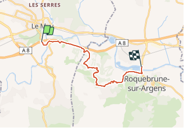
Trail Walking of 10.6 km to be discovered at Provence-Alpes-Côte d'Azur, Var, Le Muy. This trail is proposed by Danielba .
Photos


Positioning
Country:
France
Region :
Provence-Alpes-Côte d'Azur
Department/Province :
Var
Municipality :
Le Muy
Location:
Unknown
Start:(Dec)
Start:(UTM)
303083 ; 4815162 (32T) N.
Comments